The eve of distraction


Years of training.  3500 miles of walking.  Thousands of hours of planning, poring over routes, images and notes.  Direct-depositing my paycheck to REI for two years.  And now here we are.  The Long Walk Home was intended, from the beginning, to be a strategic pause … a time to reflect, regroup, re-align, and just generally be distracted from what I would call a now-irrelevant lifestyle.

My buddy, David, and I will dip our heels into the Atlantic Ocean tomorrow morning at Cape Henlopen State Park.  Then we’ll face west, put one foot in front of the other and make the first of roughly six million steps.  Somewhat auspiciously, the weather forecast calls for temperatures in the low 20s.  I’m sure that in a few months, when I’m fighting satanic heat in the Great Plains I will recollect fondly the cold we’ll face tomorrow in Delaware. But right now, after historic snows back in Oregon and several stints of failed heating systems in our brand new home in Bend, 21 degrees is just a little cooler than what I’d hoped for.  Oh well, this is just the first of what I’m sure will be many meteorological surprises.


So, the countdown begins.  And just for giggles and kicks, here it is, in a unique format:

10 – the number of times in the last week I’ve asked myself why I’m doing this…

9 – friends who’ve guaranteed they will join the walk somewhere along the line (we’ll see how that changes!)…

8 – yarn stores per day that Alanna expects to visit …

7 – months I’ve ‘budgeted’ for the walk … could be more, could be less, doesn’t really matter …

6 – pounds of Aleve I’ve packed …

5 – pairs of shoes I plan on wearing out (and, oh by the way, Keen’s, I’m still waiting for that endorsement contract!) … 

4 – time zones I’ll pass through … that’s why I’m walking east to west: I’ll save three hours that way! …

3 – years of training,  or, more correctly, walking in circles and spirals throughout the DC area …

2 – good friends, David and Peg, who’ve been so generous, and will be great traveling partners …

1 – absolute saint of a wife, whose motive for supporting me is still something of a mystery.

That’s it, my friends.  My next post will be along the trail.  The route’s still the same as indicated in the earlier post, but the dates have changed (later by a month, now).  For those eager to track us more regularly and more accurately, my InReach tracker will be posting my position every ten minutes to a web site accessible to my friends on FaceBook.

Horace Greeley said, “Go West, young man, go West. There is health in the country, and room away from our crowds of idlers and imbeciles.”

Willie Nelson was “Goin’ places that I’ve never been, Seein’ things that I may never see again.”

And, of course, in light of a sixty-something year old beginning this goofy endeavor, I can only quote Luis Bunuel, who said, “Age is something that doesn’t matter, unless you are a cheese.”

Happy trails!

False start

“No battle plan ever survives contact with the enemy.”  Helmuth von Moltke.

fullsizerenderIn this case the enemy is the forces of nature. With Bend, Oregon experiencing one of the worst winters in a quarter century, the snow and ice has delayed construction of our new home. The originally planned departure date of 3 February for the long walk home has therefore been postponed to 3 March.

Too much to do right now to post a lengthy blog, but rest assured, the Long Walk Home starts in just over a month!

The Route

A number of friends have asked to see the details of the route I’ve planned for the walk.  Below is a screen shot of the Google Earth rendition of the route, including waypoints for each day, as currently scheduled (assuming a 3 FEB start):

googleearth_image

I also have the very detailed “turn-by-turn” tracks for each of the ~50 legs of the walk, but I’ll save that for those who plan on joining me.

Enjoy!

The Consummate Walker

This blog is about walking, so today I want to remember a walker.  My Mom, Thelma Spinrad, passed away on Friday night, November 18th, 2016, just a few months short of her 100th birthday.  

Mom, having a little fun, about 10 years ago

I’m pretty sure I inherited my passion for walking from Mom. She lived her whole life in New York City, never once having a mailing address outside of the Big Apple.  In fact, she died just a short distance from where she grew up, in the Bronx.  She loved walking the streets of the city.  I have great memories of strolling with her in uptown Manhattan, across town to Chelsea, down to the village, to the Lower East Side.  Even well into her late 80s, Mom was always up for a walk.  And remarkably, for a woman who measured just about 5 feet tall (in heels … with a hat on!) she was usually the pace-setter.  

I have no idea how far Mom walked through her life, but I wouldn’t be surprised if it’s measured in light years (FitBit  would probably have to define a new badge for her total distance).  As an aside, when she moved out of her apartment four years ago, we noted that her exercycle – a first generation job with only two pedals, a wheel, handlebars and an analog odometer … that’s it – had over 20,000 miles recorded on it!  She used that when it was too cold or wet to walk, so you can imaginary what her aggregate share of shank’s mare miles must have been.

If you’ve been reading this blog in the past, you know that I intend to start The Long Walk Home on February 3, 2017.  That date was chosen for several minor reasons and one particularly meaningful one: it is Mom’s 100th birthday.  I never expected her to live to see that date, and her passing last week was, in fact, a blessing.  But rest assured that on Friday, February 3, 2017, as I dip my heel into the Atlantic Ocean, the picture in my mind will be of my favorite walking partner, my Mom.

The Gear

In her landmark book Longitude, Dava Sobel provided an inspiring history of the need for, and development of the machines that allowed sailors to finally measure time with the reliability needed to ascertain with some accuracy, their position east or west in order to map their discoveries of new lands.

Travelers have always relied on gear to make their treks efficient, comfortable and safe.  Archaeologists have volumes of stories about discoveries of the remains of ancient peoples, where, in addition to the bones, they found primitive alidades and transits for navigating among landmarks.  Thousands of years ago, Pacific island peoples developed wonderful and elegant tools to assess the wind and waves to ensure they were going the right direction.

images.jpeg

Years ago, when I was working for the Oceanographer of the Navy, we learned that there was a crisis brewing in the fleet, around the loss of skills for navigation.  The gear had advanced, but the knowledge and training of the systems hadn’t kept up.  In one case, a large Navy ship ran aground overseas (and, no kidding, the official Naval message read “WE HAVE HIT THE CONTINENT”) because the ship’s navigation system had not been set for the appropriate datum, that is, the reference for GPS in any particular area.  In another infamous case, a grounded Naval aviator, who had ditched behind enemy lines, knew that he had to determine his location, but feared that if he turned on his GPS it would inadvertently transmit his location to the enemy; he was unaware that the GPS was only a receiver.  At that point, the Oceanographer of the Navy (RADM Dick West … a real ‘sailor’s sailor’) initiated a major effort to re-educate Naval forces on navigation principles.

So, what’s my point?  Well, it’s about having the right gear and knowing how to use it.  Now, I don’t expect to be so lost that I can’t tell east from west, and, unless this year’s Presidential election really gets out of hand, I don’t expect to find myself behind enemy lines, but I do like the idea of having some state-of-the-art tools to make my walk, well … efficient, comfortable and safe!  Consequently, I’ve spent the better part of two years assessing what’s out there, and testing, rejecting and selecting the kit that best suits my needs, and assuages my concerns.

Here we go …

WARNING TO THE READER:  There’s a pretty high geek factor in the rest of this blog, so I fully understand if some readers simply hit “ESCAPE” at this point.  But for those of you with an interest, here goes.

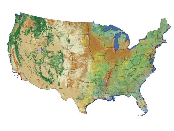
The route I’ve planned is a real hybrid of roads and trails.  Robert Moor wrote in his wonderful book On Trails that trails don’t just arise randomly, but are the result of an intelligence passed from one generation to another, or even from one species to another.  Would that I could count on such wisdom of those who went before me, but the fact of the matter is that there really is not a lot of collective knowledge regarding the best route for walking from Delaware to Oregon.  The American Discovery Trail (http://www.discoverytrail.org) is a fine collective characterization of how to walk to Southern California from the East Coast.  But, not much interested in a 1500 mile detour from my designated designation, I learned that I needed to define my full route myself.  For that, I turned to authoritative sources such as Google Earth, and the Rails-To-Trails Conservancy (RTC, http://www.railstotrails.org).  The former, of course, is the quintessential geographic information system for the masses.  The RTC is a great group who’ve worked tirelessly to pass laws and raise funds for converting old railroad tracks into trails.  I started planning the route by doing the most logical thing any traveler should do: draw a Great Circle.  I figured if I could adhere closely to a Great Circle route between Delaware and Oregon I’d be minimizing unnecessary wandering.  With that wonderful arc plotted (and, of course passing through lakes, over mountains and across superhighways) I then used RTC on-line resources and Google Maps to find the closest paths, trails, and byroads, and proceeded to lay out 51 legs of blazed paths to define the 3154 mile route.  With the route established, I needed to make sure that: 1) I stayed on the route, and ; 2) my friends and family could access the route and know where I was on it at any given time.

In simple terms, this meant that I needed to be able to navigate, track/situational awareness, and communicate.

• Navigation = Plotting the route

• Tracking/SA = Following that route … and knowing that I’m following that route

• Communication = Letting others know I’m on the route.

That’s where we get into the cool gizmos.

I have three critical tools that I’ll keep with me at all times: my iPhone 6S, a Garmin EPIX, and a DeLorme InReach Explorer :

iPhone 6S with the GPS Tracks app  (http://gpstracksapp.com)– for navigationScreen Shot 2016-10-22 at 6.39.16 PM.png

Once I determined the optimal route – by using the Rails-to-Trails extensive database of trails, along with Google Maps application providing walking directions – I saved each leg of TLWH as a file (.kml, or .gpx, or .kmz format) in my iCloud account, and can export it to the GPS Tracks app on my iPhone.  That gives me a very clear, and highly resolved track to follow to get to and from each pre-planned waypoint on the walk. I’ll always be able to confirm whether I’m on track or veering into uncharted territory.  This app also has a very nice set of track statistics that it acquires as you walk (pace, elevation gain, etc.).  Additionally – and this is a really nice feature – the app automatically sends the tracked route to both an iCloud and DropBox account.  That means I never need to worry about archiving the route.  When I want to look back at where I walked, five minutes after I’ve passed, or ten years from now, I’ll have the route permanently stored in the cloud.  The only problem with this system is that it requires me to take out the iPhone every time I need guidance… Not a problem in Nebraska, where I’ll basically be walking straight for 300 miles, or on clear trails like the GAP in Pennsylvania, but there are some legs that require navigational adjustments every 3 or 4 miles.  That’s where the tracking and communication come in.

GARMIN EPIX watch (https://buy.garmin.com/en-US/US/into-sports/hiking/epix-/prod146065.html) – for tracking and sustained situational awarenessScreen Shot 2016-10-22 at 6.39.54 PM.png

As of mid-2016 this watch was the only wearable GPS device with full real-time mapping capacity.  And, it’s linkable (via Bluetooth) to my iPhone.  So, now, that same track that I saved into the GPS Tracks app can also be loaded onto the EPIX.  That way, on any given leg, all I need do is check my wristwatch to see if I’m still on track.  It’s also got some cool widgets, such as a weather tool that will warn me when there’s a storm warning within 30 minutes of my predicted track.  It’ll also, apparently, measure my pulse and blood pressure if I so desire, but somehow I don’t think that will be something I want to necessarily know.  Although, I suspect the local medical examiner could use that information when they find my body beside some steep trail side and need to assess cause of death!  But before they ever find me, I’ll need to have a way to communicate my position and status.  That’s where the coolest gadget comes in …

DeLorme InReach Explorer (http://www.inreachdelorme.com/product-info/inreach-explorer.php?gclid=CPLE0cex788CFY1bhgodiEoFbA) – for communicationScreen Shot 2016-10-22 at 6.40.32 PM.png

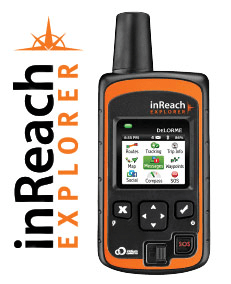
This is a hybrid GPS receiver, with an Iridium communicator.  It transmits my exact position continuously, at frequencies as high as every two minutes.  These data are sent via the Iridium satellite communications network.  This is important, since it will work anywhere in the world, anytime.  I know, because I tested it last year in the Antarctic.  I kept – somewhere in my files – a transmission showing my position as -89.999 degrees South, when I was standing at the exact South Pole.  The positions can be sent to anyone I’d like, via text, or Facebook, or to a password-controlled website with a mapping feature. Perhaps even more important, this nifty little device can transmit and receive text messages – again, from anywhere in the world.  That, coupled with an SOS feature, adds a nice element of security.  In short, the Explorer is my tether to the rest of the world.

There are some other cool devices that I’ll include.  Perhaps the cleverest is my GoTenna (http://www.gotenna.com/).  Screen Shot 2016-10-22 at 6.41.25 PM.png
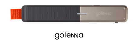
The last mile of communication is often the most important.  The DeLorme Explorer will allow me to tell others where I am within the error circle of GPS, but what if the folks I’m trying to communicate with have only cell phones, and don’t happen to be walking around with an Iridium satellite phone?  Well, the smart folks at a startup called GoTenna, realizing that even without cell towers around, our cell phones are still powerful transmitters/receivers.  They’ve produced a Bluetooth-linkable antenna that basically converts your phone into a texting walkie-talkie, even where there’s no cell coverage.  If you and a partner have matched GoTenna antennae (about the size of a fountain pen) you can communication over a couple of miles.  So … when Alanna and I are trying to communicate at the end of the day in the wilds of Wyoming, no problem.  Just start texting with the GoTenna, and we’re connected.

Other stuff

That’s it for the unique high tech gear.  Of course I’ll have a good camera, a Nikon Coolpix S9900, which automatically tags my photos not just with date, but also GPS location, and compass orientation.  I’ll make sure all the best photos end up on this blog.

I also carry the usual stuff that every good hiker carries.  My package includes:

• REI Flash 22L pack – I can’t even tell I’m carrying this thing.  I’ve spent more time with this pack over the last two years than I have with Alanna.

• Fitbit – I’m figuring I’ll add about 6.5M steps to my tally – what’s the badge for that?

• Footwear – Silk liners, Smartwool heavy duty hiking socks, custom-designed orthotics, and Keen Targhee II hiking shoes.  Ain’t nobody happy if the dogs ain’t happy

• Lots of other small stuff – headlamp, cooling bandanna, packable down coat, packable rainwear, pepper spray,  whistle, etc.

Before I close out this posting, however, I need to go back to a comment made in an earlier blog.  Last year, after finishing the C&O Canal, I listed some lessons learned, including one, where I said that no flask has been invented that will keep coffee warm all day.  Well, recently, my co-worker and friend, Emily Larkin, told me I was wrong, and that Hydro Flasks (http://www.hydroflask.com) would do that.  So, having a few hours to kill on a recent Saturday, I did an experiment.  Here are the results.

screen-shot-2016-10-22-at-6-36-19-pm

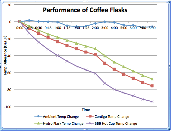
So, I owe Emily an apology.  Hydro Flask did outperform what I thought was the best coffee flask on the market.  You will note that this experiment was clearly done under highly controlled conditions, and while I’m not sure my kitchen adheres to ISO9000 standards, it’s still pretty clear the Hydro Flask will now be my coffee thermos of choice!  Can’t wait to test it on the trail.

Big Savage

DSCN0891I lied.

Several posts back I suggested that there was only one section of the route for the Long Walk Home that was not “walkable”: The Chesapeake Bay Bridge.  Well, I must confess that for some time I’ve been aware of one other impassable section … I was, however, in denial, and felt that surely I could find a way to walk this section.  Turns out, the Big Savage Tunnel, along the Great Allegheny Passage (GAP) – just north of the Mason-Dixon line – will be closed in the winter.  To make matters worse, the bypass route is along narrow, windy roads, not conducive to wide-bodied walking.  The other alternative is to hike over Big Savage Mountain … in the winter … along a steep, rocky, treacherous path … without a sherpa. What to do?  Well, if hiking across Chesapeake Bay on the one day when it’s possible is acceptable behavior, then why not walk through the Big Savage Tunnel on a nice summer day, and check that off as “DONE”? Hey, I’m making the rules, right?

Okay, so the next question was how to do the one-way walk over about 10 miles between Frostburg, MD and Deal, PA.  The GAP doesn’t have a lot of access by roads, so Alanna and I figured we’d park in Deal, take a shuttle ride down to Frostburg and hike back.  “No problem” said the bourgeois capitalist money-grubbing exploitative nice young man at the shuttle van company … “That’ll be $245”.  “WHAT?”  For that much money I could probably find that sherpa to carry me down the trail.  So, once again, Saint Alanna came up with the solution.  She’d walk half-way down the trail with me, turn around and get the car, and meet me at the other end of the walk.  For that she only wanted $100.

We decided to start in Deal and walk to Frostburg.  That was easier logistically, since there was a big festival going on in Frostburg (more on that later), and parking there would be difficult.  This route is also a bit easier since it’s virtually all downhill from Deal to Frostburg.  Minor detail that irked me a bit, but I got over it pretty quickly.

So … Big Savage.  What’s with that name?  I’ve got to admit that every time I hear “Big Savage” I can’t help but think of the incomparable Paul Lynde on Hollywood Squares (for the younger readers – that is to say, not-yet-senile readers, check out some of the YouTube videos of him … he was hilarious, and in one memorable example, the emcee, Gary Marshall, asked Lynde “According to Compton’s Encyclopedia, when Columbus returned from his famous trip, he brought Queen Isabella six naked savages, some animals, some plants, and something valuable. What was it?” to which Paul Lynde responded: “I’ll say the six naked savages“).

Actually, Big Savage mountain is the larger of two ridges in an anticline along the Mason-Dixon line, and was named after the colonial surveyor of the 18th century named John Savage (who, apparently, narrowly escaped cannibalism in the area in 1736… I suspect he didn’t have $245 for a shuttle either). The mountain is also the site of an infamous 1962 crash of a B-52 that was carrying nuclear bombs; 3 of the 5-man crew died, two of them from exposure after parachuting out of the disabled aircraft, and the bombs were recovered intact.  DSCN0909The tunnel going through the mountain is 3295 feet long, and was opened in 1912 as a railroad tunnel.  Rail traffic stopped in 1975, but Amtrak kept selling tickets until 1982 … just kidding about that last part.
DSCN0872

And even more interesting, the mountain is right at the Eastern Continental Divide; all raindrops to the west go to the Gulf of Mexico, those on the east go to the Atlantic.  Cool!
The hike was beautiful.  Remarkably, we saw lots of bicyclists but not one other hiker.  Alanna walked from Deal to the end of the tunnel (about 3 miles) then turned around.  I kept going to Frostburg, for a total distance of 10 miles.  I passed the Mason-Dixon Line, through one more tunnel (the Borden Tunnel), and into Frostburg.

Just before Frostburg, I also walked through an enchanting little park with several fun sculptures.

In Frostburg, the annual Soap Box Derby was underway.  Alanna and I enjoyed an ice cream and watched kids of all ages race down main street.  There was a hot dog eating contest, people in July 4 get-ups, and just a generally wonderful festive mood throughout the town.  We thought Norman Rockwell would approve.

So, one more chapter in the Long Walk Home is complete.  Sometime around the end of February next year, we’ll be back in Frostburg.  I’ll drive around  Big Savage Mountain and will remember fondly this wonderful walk on a summer day.

Thanks, Bill!

DSCN0165

941020_10205817606418558_3048834791557707939_n
My route, from Sharpsburg to Cumberland

In 1954, U.S. Supreme Court Justice William O. Douglas learned of a plan to build a highway over the Chesapeake and Ohio (C&O) canal. The canal had stopped operations about 30 years earlier and Justice Douglas was upset that the natural beauty of that route might be obliterated and paved over.  So he invited a group of reporters to walk the length of the canal with him, hoping to convince them of the value of preserving the unique character and sheer splendor of the path.  It worked.  The C&O Canal is now a National Historic Park, and the full 184.5 mile tow path (where the mules once trod, pulling the specially designed canal boats) is just about the best test route for planning The Long Walk Home that I could imagine.  So, last Saturday I started at milestone 80 on the path, with the intent of walking about 100 miles in one week.

Starting point at Sharpsburg, MD, near the site of the Civil War battle of Antietam

And I did it.  So, thanks, Bill … I couldn’t have done it without you!  Oh, yes, one other thing.  Justice Douglas was also smart enough to marry a girl from Oregon.  Now I’m definitely feeling a kindred spirit with this guy!

The walk was something of an experiment.  We were testing several “concepts of operations”.  For example, at day’s end Alanna was to pick me up at predesignated sites, each carefully labeled on a paper map, with coordinates entered into the car GPS system.  So, the first day, after a good hike of 15 miles, I end up at our rendezvous point.  No Alanna.  No other cars.  No people.  Just a single winding road going straight up, perpendicular to the trail.  Fortunately, we had decent cell service, and I learned that Alanna was waiting for me at the gate to a private rod and gun club, on whose property I was trespassing!  Oh well, nothing ventured, nothing gained.  I walked the last half mile up the hill, on a private road, waiting for some itchy-fingered gun club enthusiast to mistake me for a backpack-wearing deer.  Safely back at the car, I agreed that we’d do a little more research on the future meeting points!

DSCN0140
20 down, 85 to go!

We also tested all of our communications and navigation systems and protocols.  Never one to trust any single technology, and convinced I was going to end up writhing in the throes of a massive heart attack on the trail, with no other living soul within miles, I wanted to make sure we had ways of communicating wherever we were.  Cell phone service stopped, for all intents and purposes, about 20 miles into the hike.  But my Delorme GPS/Iridium communicator was great.  Limited to short text messages, we could keep each other apprised of status from anywhere.  We soon learned, however, that this system had anywhere from a 5 to 30 minute lag in message transmission.  Not a problem if you’re just notifying each other that all is good, but potentially an issue with a more serious communication (“No bears yet, but hearing banjo music!”).  And finally, we had, as a last resort, a new device called a GoTenna: a very clever creation of a small startup company.  The GoTenna turns your cell phone into a text walkie-talkie.  In the absence of cell service, you can still communicate between cell phones which are connected to their respective GoTennas.  The challenge of course is knowing when each of you is without cell service, and being within about 2-3 miles of each other.  At that distance one could probably just scream loudly and be equally effective at communicating.  We only tried the GoTennas once … well, Alanna hooked up hers, thinking I would do the same.  I, of course, was obliviously hiking along, without a worry in the world.  I was 15 minutes late arriving at our meeting point, and Alanna was convinced I had probably fallen into a ravine, where a pack of hungry dogs were devouring the last of my remains.  She gave up on the GoTenna and started walking down the trail, only to find me about ten minutes later.  I was whistling “Hi Ho, Hi Ho” and she was spitting nails.  We agreed after that on a regimen of regular status updates every few hours.

The hike was a delight.  After the second day (about 30 miles in), I barely saw anyone else.  In fact, on days 3,4,5 and 6 I only saw one other person on the trail.  He was the kind of guy my dad would have called a hobo.  He had a beat up bike with a two-wheeled trailer, which I suspect he used as his mobile sleeping quarters.  I passed him at one of the rest areas on the trail (sites with a picnic table, a fire pit and a port-a-potty).  It was early in the morning and he had a fire going, but no tent.  We didn’t speak, but exchanged head nods.  A lot gets communicated with a head nod. His said, “Only a homicidal maniac would be hiking this trail at this time of year … please don’t kill me”.  My nod said, “Only a homicidal maniac would be camping on this trail at this time of year … please don’t kill me”.  Never saw him again.  Four more days of pure tranquility, with perfect hiking weather.  The mornings were cool and a bit foggy, and the afternoons warmed up just a bit.

The trail was gorgeous.


DSCN0138 DSCN0127 DSCN0122 DSCN0148 DSCN0139 DSCN0149 DSCN0161 DSCN0196

Encouragingly, my body handled the walk better than I expected, and there was really only one surprise.  It happened to be a surprise that lasted a full week: each morning some different part of my body expressed its displeasure in a unique and effective manner.  I’m convinced that as I slept each night my body parts convened a meeting and elected that part which was to inflict more pain than the others in the coming day.  Not unlike the current Republican party, there was no shortage of candidates for the top honor each day.  The first two days it was the little toes of each foot.  They formed a coalition and arguing that they represented a plurality of 20% of the toe constituency, they would express some discomfort on behalf of all the other toes.  By day 3 they conceded to the right fifth metatarsal … clearly a minority candidate, but one who could easily control the direction of the rest of the body (literally!).  That pain gone by mid-walk, the calves and thighs united in a major muscle movement and were content with a low and slow burn, culminating with the threat of cramps on day six, but never really living up to that threat.  Finally, by the last day, one heel, in a particularly desperate motion voted for a blister, and was barely noticeable in the final polls.  By week’s end, all the parts agreed that there was nothing more they could do, and I marched on almost as good as new.

Walking for 6 hours a day can get somewhat monotonous if not for the scenery (like the photos above) and the wildlife.  I ran into, jumped, and was startled by hundreds of deer (including one albino yearling … I hadn’t seen one of those in at least 10 years),

lots of ducksDSCN0215


one surly raccoonDSCN0158

surprisingly frequent beaver signDSCN0153DSCN0194,

and, in one particularly exciting moment, a river otter

DSCN0170

River otters were virtually gone from this area until the 1980s when they were reintroduced.  This fellow had some choice comments for me and my kind.  I asked him not to profile me in such general terms, but he was not willing to debate and shortly after this photo, he submerged not to be seen again.

I also had a rare treat in the Paw Paw tunnelDSCN0175.  This is a magnificent engineering marvel, built from 1834-1850 by thousands of immigrants.  The tunnel, 0.6 miles in length, was part of the canal system, and allowed commerce to bypass many miles of the winding Potomac river.  The tunnel itself is arrow-straight, unlit, and early in the morning, eerily echoing of the voices of 19th century workers.  It’s also home to a thriving colony of bats – I think they were Eastern Small Footed bats (Myotis leibii)DSCN0255, and as you can see from this picture, they don’t seem to be suffering from White Nose Syndrome, which is devastating much of the globe’s bat populations. The tunnel was such an interesting walk that after I finished the hike on Friday, Alanna and I walked back through the Tunnel so she’d get a chance to enjoy it

Like I said in a previous post, this was certainly not any kind of grueling march.  By the time I’d finished I’d gone a bit over 109 miles.  My GPS Tracks app shows the final stats:DSCN0226

DSCN0224
Cumberland, Maryland

I averaged about 2.9 miles per hour.  Total elevation gain was a whopping 231 feet (not a whole lot more than the Washington Monument at 179 feet).  With all of the minor ascents and descents, I climbed an aggregate 16,857 feet, and descended an aggregate 16,626 feet.  My longest day was just short of 18 miles, and the lightest was about 11.5. The weather was fine (as predicted …  thank you, NWS!) and the trail conditions couldn’t have been better.

DSCN0228
At milepost 184.5, the end of the C&O Canal

As I close this blog, I thought I’d share some important observations.  Maybe these will help others; my top lessons learned were as follows

  1. Beef jerky can go bad
  2. Don’t try a new brand of socks during a long hike … it offends your toes!
  3. There is no thermos that can keep coffee warm for 6 hours
  4. Ducks (the actual birds, not my beloved University of Oregon fans!) are stupid
  5. The National Park Service is the taxpayers’ greatest bargain
  6. Hotels without hot tubs should be illegal
  7. Free breakfasts can have a price
  8. When your wife expresses interest in becoming a massage therapist, say “yes”
  9. New Years Eve is overrated
  10. And finally … Bill was right!


See you on the trail!


A dry run … well, really a wet walk

A bit more than a year ago, a friend of mine asked, “What’s the longest you’ve walked, to prepare for this trek?”  At the time my longest walk was just under 10 miles, and the day after hiking it, I felt every step in my aching muscles.  Some 1600 miles and 15 months later, I can proudly say that I’ve done several day hikes of more than 20 miles, and on two separate occasions I completed multi-day hikes of more than 15 miles each day.  Feeling pretty good about endurance.  But that still proves nothing regarding the stamina I’ll need for The Long Walk.  So, starting on this Saturday (Boxing Day) I’ll try to do a 100-mile hike in one week, averaging about 15 miles per day.  I’ve chosen the C&O Canal Towpath as the test grounds … not exactly the Bataan Death March, but a good place to uncover my weaknesses, and to test some of my gadgets (more about those in a subsequent post).

image

The bod, on the other hand, well, that’s been an interesting development.  My leg muscles and joints are doing great.  Like case-hardened steel pistons, my thighs and calves are honed, toned and tempered … ready to conquer leagues and leagues of legwork.  The feet … well, they won’t be winning any beauty contests.  Details notwithstanding, let’s just say between the bruised toenails, calloused heels and tired metatarsals, the old dogs look more like a Jackson Pollack work than part of the human anatomy.  And then there’s the upper body … while the lungs are holding out well, walking doesn’t really do much for the upper body, so try imagining a pear shaped pillow sitting on top of those steel pistons and you’ll get the picture.  Seven days of walking might help with some of that.

We’ll test our fundamental concept of operations: Alanna will drop me off every morning and pick me up in the late afternoon at a predetermined rendezvous point.  I have no idea what she’ll do during the roughly 6 hours that I’ll be walking but I’ve noticed she’s been surfing the web a lot lately and bookmarking all yarn stores within a 30 mile radius of the towpath.  God help me!

Now, I’m guessing your wondering about the title of this post.  Well, by all rights, the walk I’m taking is – by any definition – a dry run.  But I’m not running, so maybe I should just call it a dry walk.  However, my good friends at the National Weather Service have assured me that a strong pattern will deliver record-breaking heat and precipitable water (that’s their way of saying rain) FOR THE WHOLE WEEK!  So, it makes complete sense to call this not a dry run, but a wet walk!

Wish me luck… I’ll keep you posted.

image

The First Leg

imageO

One of the complicating factors associated with planning this long walk is that of the 3154 miles on the trail, there are 6 that are “un-walkable” for 364 days a year: those going across the Chesapeake Bay.  But … once a year there’s a sponsored Walk Across the Bay.  The southern span of the Chesapeake Bay Bridge is closed for about 6 hours, and it makes for a very nice 10K run/walk.

So, on November 8 of this year, I joined about 22,000 close friends on a gorgeous, sunny day to walk over the bridge.  A light breeze from the west was surely an omen of good things to come.

image

Odd as it sounds, I had an overwhelming sense of realism as I started the walk.  While I won’t begin the full Long Walk Home for over a year, the Walk Across the Bay was, for all intents and purposes, my first leg.  Those 6 miles, when added to the 3148 I’ll complete in 2017, would make the long line from Atlantic to Pacific complete.  And while my walk across the Bay went west to east (from Westinghouse Bay to Stevensville) there’s no questioning that the path I trod was a critical link in the chain I would spend 7 months building.

I finished in one hour and forty five minutes.  In fact, it took longer to ride the shuttle bus back over the Bridge than it did to walk the span.  I was finisher number 18896 out of 21030.  I passed 182 other participants and I was passed by 565 (I didn’t count … that’s what the official web site for the Walk emailed me later that day!).  The walk itself was fine.  Nice views, but after about 45 minutes, quite honestly, it got pretty boring.  Sky above, water below … more sky above, more water below.  As I approached the finish I felt I’d checked an important box.  With about 200 more legs to go, I’d finished Leg One.

image


A Long Walk Home

I’ve had the idea of taking a long walk for quite some time.  But, it was only during my solo drive from Corvallis to Chevy Chase last June that I began to think seriously of walking across America.

I thought the idea was just a fantasy or pipe dream, but found that it kept haunting me.  So, I started taking hikes… first just around the neighborhood, then for much longer distances.  One day, last fall, after walking about 17 miles in just under 6 hours I realized that this idea was more than idle whimsy, that maybe I really could do this.

I’m not a 20 year-old who can strap on a backpack, buy a case of power bars and start hiking.  I’d like to think I’m in touch with the physical limits of a 61 year-old body.  But, of course, what I lack in strength, flexibility or stamina, I make up for in financial stability!  That means that while my 20 year-old trekking alter ego humps a 40 pound pack, and pitches camp every night, I can sleep in hotels and have a support crew (well, one very loving wife) carry what I need in an accompanying (air-conditioned) vehicle; not as adventurous, perhaps, but certainly every bit as much a cross-country hike.

So, I am committed to doing this.  The walk will go from Rehoboth Beach, Delaware, to Nye Beach, Oregon.  I will start on 3 February, 2017, and will give myself between seven and eight months to complete the journey.  February 3, 2017 will be my Mom’s 100th birthday.

I will plan as much of the trip as I can: routes, schedules, stopover sites, equipment, etc.  I’ve already started defining the route by joining or researching groups such as the American Discovery Trail, and Rails-to-Trails.  I’ve purchased some hardware (Delorme inReach Explorer GPS/Iridium communicator) and apps (Earthmate).  And most importantly, I’ve begun something of an informal training regimen.  Since October, 2014, I’ve logged over 1500 miles of hiking, mostly suburban, mostly in Maryland. My longest hike is 21 miles and I’ve had one 3-day run of 35 miles, and a 2-day weekend of 30 miles.  Clearly that’s just a preliminary effort.  However, it’s given me the experience to learn what clothes and gear I like, and since I’ve been hiking consistently throughout the year, I know what works in cold, heat, snow, ice, rain, traffic, mud, etc.  And with only a handful of blisters, bloody feet, and leg cramps, I now have a good idea, also, of just how much moleskin, Aleve and Neosporin I will need to carry.

I’ll end this first blog entry with the question I’m asked repeatedly when I tell friends and relatives that I’m going to walk across the US: Why?  There’s a long answer and a short answer.  The long answer is that I’m ready to decompress, self-reflect, get in better shape, and see more of America.  After nearly four decades of a very rewarding career, lots of tight schedules, packed calendars and global travel, I’d like a healthy chunk of time with no agendas, meetings, conferences, or detailed plans, except to wake up each day and walk west.  The short answer to the question “why” is simply “who cares … it looks like fun”  What’s wrong with that?keens